Version: 3.22.3
Developer: Strava Inc.
 Verified App
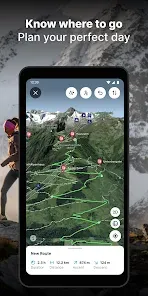


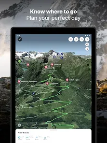
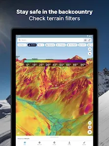


"FATMAP: Ski, Hike, Bike" is a comprehensive outdoor navigation app designed for adventure enthusiasts. One of its standout features is the 3D mapping technology, which provides users with detailed topographical maps that enhance route planning and navigation. This feature allows users to visualize terrain in a realistic manner, making it easier to assess the difficulty of trails and slopes.
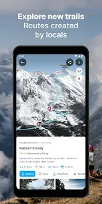
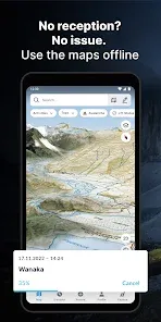
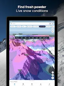
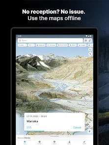
Another key feature is the extensive database of trails and routes for skiing, hiking, and biking, which is user-generated and regularly updated. This ensures that users have access to the latest information on trail conditions and safety. Additionally, the app includes offline map capabilities, allowing users to download maps for use in areas with limited or no cellular service.
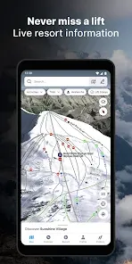
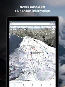
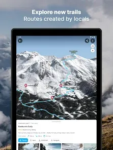
FATMAP also offers a social component, enabling users to share their adventures and discover new routes from fellow outdoor enthusiasts. The app includes safety features such as avalanche risk assessments and weather updates, which are crucial for planning outdoor activities. Overall, FATMAP combines advanced technology with community-driven content to enhance the outdoor experience.
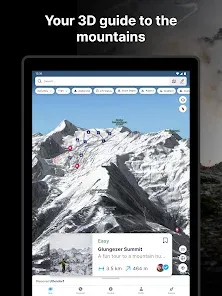
Using "FATMAP: Ski, Hike, Bike" is straightforward and user-friendly. First, download the app from your device's app store and create an account to access its full features. Once logged in, you can explore the interactive map, which allows you to zoom in and out to find trails and routes that suit your preferences. You can filter trails based on activity type, difficulty level, and user ratings, making it easy to find the perfect adventure.
To plan a trip, simply select a trail and view detailed information, including elevation profiles, distance, and estimated time. You can also download maps for offline use, ensuring you have access to navigation even in remote areas. Before heading out, check the app for real-time weather updates and safety alerts, such as avalanche warnings. After your adventure, you can log your experience, share photos, and provide feedback on the trail, contributing to the community and helping others in their planning.
Overall, FATMAP is designed to enhance your outdoor experience by providing essential tools and information at your fingertips, making it an invaluable resource for outdoor enthusiasts.
Like any app, "FATMAP: Ski, Hike, Bike" has its advantages and disadvantages. One of the primary pros is its advanced 3D mapping technology, which offers a realistic view of terrain and helps users better understand the trails they plan to explore. The extensive database of user-generated content is another significant advantage, as it provides up-to-date information on trail conditions and safety, enhancing the overall experience for users.
Additionally, the app's offline capabilities are a major plus, allowing users to download maps and access them without cellular service, which is crucial in remote areas. The social aspect of the app encourages community engagement, enabling users to share their experiences and discover new routes from others.
On the downside, some users may find the app's premium features, which require a subscription, to be a drawback. While the free version offers valuable tools, the full experience is only available through a paid plan. Additionally, the app may consume significant battery life, especially when using GPS and 3D mapping features. Lastly, while the user-generated content is beneficial, it can sometimes lead to inconsistencies in trail information. Overall, FATMAP is a powerful tool for outdoor enthusiasts, but potential users should weigh these pros and cons before diving in.
Spotify Wrapped is an annual feature that summarizes your listening habits, including your most-played songs and artists of the year.
To create a playlist, click "Your Library," then "Playlists," and select "Create Playlist." Add songs by searching or browsing.
Yes, with a Spotify Premium subscription, you can download songs and playlists for offline listening.
Spotify offers a free tier with ads, as well as a Premium subscription that removes ads and adds features.
Click the three dots next to the song, select "Share," and choose your preferred sharing method, like social media or a link.